ECL produces large seas and gale force winds
Thursday, 24 March 2005
An east coast low (ECL) developed in the Tasman sea on Monday, originating
off the far north coast of New South Wales. The system moved southwards and by
Tuesday it rested off the central coastal regions of NSW. It intensified and
slowly moved northwards overnight Tuesday. It produced winds in excess of
100km/h and seas up to 4 metres. At 5pm Tuesday, the centre pressure of the ECL
was 996hpa, making it almost equivalent to a category 1 tropical cyclone.
The rainfall from the system was mostly confined to the coast with Nelson Bay
recording approximately 90mm and Nobbys Head recording 62mm since Tuesday
night. Maitland has recorded 22mm and Scone has only recorded 4mm over the same
time period. The max wind gusts from the system was 102km/h from the SSW
recorded at Nobbys Head at 5am yesterday. Norah Head AWS also recorded a wind
gust of 102km/h at approximately the same time.
The damages from the ECL were minimal. Slight structural damage was
report in Newcastle and other small areas along the coastline.
|
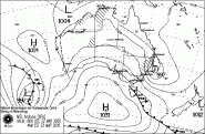
Synoptic Chart for 5am (EDST) 23/03/05 |
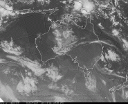
Satellite image for 5:30am (EDST)
23/03/05
|
back...
|


)
)