|
A convective pocket of cold air that moved through eastern
New South Wales brought cold, windy and showery conditions last night for a
large area of the Hunter Region. At around 7:30pm, the cold moist air hit the
southern parts of the Hunter. This cold air did not hit the Upper Hunter until
around midnight.
Due to the cold nature of the passing air mass, unexpected
snow fell on the plateau of the Barrington Tops between 11pm to 2am last night with snow depths generally between 5 to 7.5cm in the highest elevations. The
snow was only confined to the higher elevations of the Barrington Tops and there
were no reports of low level snowfalls. Light showers were observed across the
Lower and Upper Hunter overnight.
|
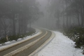
Snow that remains on the Barrington Tops from last nights
snowfall. Photo taken at 1:30 this afternoon. |

