|
|
|
Heaviest snow in 5 years: Barrington Tops
Tuesday, 28 August 2001
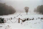
Photo
taken on the 28th near Tomalla
Click
here to see more photos.
|
Heavy snowfalls
in the last 36 hours has left the Barrington Tops and other mountain
areas very white. The snowfalls started on Sunday (26th) evening after
a cold front hit the Hunter in the afternoon. Rain fell at first, but
quickly turned to snow on all ranges above 900-1000m. By Tuesday morning
there was 20-25cm (average) of snow on the ground (drifts over 50cm)
at Hunter Springs/Tomalla, which is at an elevation of approximately
1300m. The depth of snow was the deepest since the 19, August 1996.
The roads to the higher elevations to the Tops (1400-1500m) were closed
to all vehicles. The mountains surrounding Timor, Merriwa and Nundle
all got snow, leaving them looking like the Snowy Mountains by this
morning (28th).
This type of event was
very unique in that there was a combination of heavy rain in between
periods of heavy snowfalls. This led to minor flash flooding from the
Hunter River and its catchments. On Monday afternoon (27th) heavy rain
set in on the Barrington Tops, even at elevations as high as 1300m.
This resulted in a significant thaw of the fresh snow, but after a few
hours of heavy rain, it quickly turned to snow again and left the area
in a deeper cover of snow then what it was previously. The 24 hour period
ending to 9am Tuesday, Hunter Springs reported a total of 99mm of precipitation.
This fell as a mixture of heavy snow and rain.
This event was brought
on by a significant cold front that was interacting with a trough line.
Because of the trough line and the cold front that followed, there were
an outbreak of weak thunderstorms across the Hunter on Sunday afternoon.
The cold front hit the Hunter at around 2pm dropping the temperature
steadily for a few hours after. Snowfalls set in on the elevated areas
overnight. By Monday morning the cold front had moved into the Tasman
Sea. With the combination of the high sea surface temperatures, the
trough line and the cold front, this led to a low developing off the
South Coast of NSW (see chart on left). A pool of cold air remained over Eastern NSW during this time. This
resulted in local snowfalls on the elevated areas in the Southern Highlands,
Central Tablelands, Hunter, Northwest Slopes and the Northern Tablelands.
There were reports of up to 20cm of snow in the Southern Highlands and
parts of the Northern Tablelands also.
A pool of cold air remained over Eastern NSW during this time. This
resulted in local snowfalls on the elevated areas in the Southern Highlands,
Central Tablelands, Hunter, Northwest Slopes and the Northern Tablelands.
There were reports of up to 20cm of snow in the Southern Highlands and
parts of the Northern Tablelands also. back...
|
|


)
)