|
|
|
Hunter hit by severe thunderstorms with Tornadoes
Sunday, 18 November 2001
|
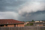
This photo
was taken from Rutherford looking west at 2:36pm
|
A
downburst (squalls caused by a strong downdraft at the front end of
a storm) produced winds in excess of 75kts (140km/h) causing moderate
damage in a path that was no wider then 5km. Salamander Bay, Corllette,
Tomaree, Nelson and Shoal Bay were the worst effected areas. The most
interesting phenomena that occurred when the storm passed through these
areas, were the tornadoes that formed across the water and then travelled
over the land. It is uncertain whether the tornadoes may have been
gustnadoes
Gustnadoes are classified
as tornadoes as they are a rotating column of air, but technically are
not tornadoes. Not like tornadoes, which often form at the back end
of a thunderstorm, gustnadoes occur at the front end and are often associated
with downbursts. There have been reports of sighted tornados when the
storm hit around Nelson Bay and Corlette. This evidence is backed up
by the irregular direction in which the trees have fallen from one area
to another and the locality of the damages. Also, a track of damage
was left in Corlette. All of this suggests the possibility of some sort
of vortex movement associated with a tornado or a gustnado. Most
of the damage that occurred were typical for wind strengths between
65-100kts (120-180 km/h), however, the winds may have been slightly
higher then this in some places.
Some of the other significant
thunderstorms occurred near Cessnock, Barrington Tops, Denman area and
western parts of Lake Macquarie. Isolated supercell storms were observed
around the Barrington Tops and the western parts of Lake Macquarie.
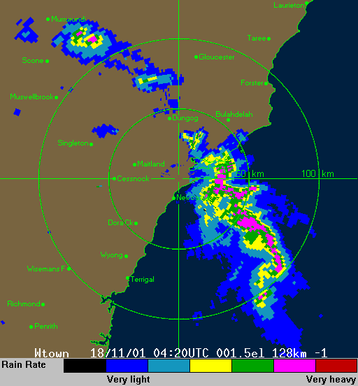
For those who are more technically minded, the Williamtown sounding
for 0000z showed that the surface lifted index (Li's) was -0.3, 500hpa
winds were blowing from 300° at 55kts while the overall Convective Available
Potential Energy was 112.
back...
|
|


